Articles

Understanding drought: the science behind a slow-building hazard

Drought is a slow‑building hazard shaped by interactions between the atmosphere, oceans and land. In this article, JBA Climate Scientist Dr Jack Giddings explores the science behind how drought develops, persists and intensifies — and why this matters for managing risk and water resilience.

A lone tree with sparse foliage standing on dry ground in front of a large sand dune under a clear blue sky.

Contents:

Drought is often described as a lack of rainfall, but the processes that drive drought are more complex. Like flooding, drought emerges from the interaction between large-scale atmospheric circulation, ocean–atmosphere variability, and land surface conditions. These processes can suppress rainfall over weeks, seasons or years, gradually reducing soil moisture, river flows and groundwater levels.

Understanding the science behind drought is essential for anticipating risk, designing early warning systems and supporting long-term water resilience.

What is drought?

Drought occurs when water availability falls below what is typical for a given region over a sustained period. Unlike sudden hazards, drought typically develops slowly, and its impacts may only become visible once water stores are depleted, putting ecosystems and livelihoods under stress.

According to the IPCC (Seneviratne et al., 2021), meteorological drought — a deficit in rainfall and changes in evaporation — leads to a net drop of water availability. This, in turn, can give rise to other forms of drought, including:

  • Hydrological drought, as river flows, reservoirs and aquifers diminish
  • Agricultural drought, as soils dry and water available for irrigation depletes
  • Ecological drought, as reduced water availability affects the local environment and wildlife.

Large-scale atmospheric drivers of drought

At its core, meteorological drought is shaped by large-scale atmospheric patterns that reduce rainfall and increase evaporation.

The role of sinking air
Rainfall is closely linked to rising air. Where warm air ascends, it cools, condenses and forms clouds. By contrast, when air sinks, it warms creating a stable inversion layer that suppresses cloud formation and limits rainfall. This downward movement of air – known as subsidence – forms and sustains the high-pressure systems that influence much of our day-to-day weather.

Many drought prone regions lie beneath zones of persistent subsidence. Subtropical high pressure systems are a key example. These semipermanent features form part of the global Hadley circulation and are associated with dry conditions across parts of Australia, south and northern Africa and south-west North America. When these systems intensify or remain stationary for extended periods, rainfall suppression increases, raising the likelihood of drought.

Large-scale ocean–atmosphere systems in the tropics
Interannual, large-scale climate modes play an important role in shaping drought risk across the tropics and beyond by altering global atmospheric circulation. Among the most influential of these are the El Niño–Southern Oscillation (ENSO) and Indian Ocean Dipole. ENSO has two phases: a warm phase (El Niño), and a cold phase (La Niña).

  • During El-Niño, warmer than average sea surface temperatures in the central and eastern equatorial Pacific suppresses rainfall in the western Pacific, often increasing drought risk in regions such as Australia, parts of Southeast Asia, southern Africa and Central America. El-Niño was a key driver of the 1991–1992 drought in southern Africa, which affected around 100 million people (WHO, 2023).
  • During La Niña, cooler than average sea surface temperatures in the central and eastern equatorial Pacific suppresses rainfall in the region, increasing drought risk along parts of the western coasts of South America, in central Asia, and across equatorial East Africa. Between 2020 and 2023, an unusually prolonged La Niña contributed to a three year drought in Ethiopia, Kenya and Somalia (WHO, 2023).
  • The Indian Ocean Dipole also influences regional drought risk. During positive phases, cooler sea surface temperatures in the eastern Indian Ocean suppress rainfall over parts of Southeast Asia, increasing drought risk there. During negative phases, cooler waters in the western Indian Ocean tend to suppress rainfall over East Africa, increasing drought risk in that region.

On intra-seasonal timescales, systems such as the Madden-Julian Oscillation and the Boreal Summer Intra-Seasonal Oscillation influence the timing and intensity of South Asian monsoon rainfall within a single season. If there are more “break” phases than “active” phases, rainfall accumulations are reduced across western and central India, which can lead to drought, as seen in 2017 (Richardson, 2020).

Together, these ocean–atmosphere patterns influence the duration, frequency and spatial extent of drought, most notably in tropical regions.

“Omega” blocking highs

Drought can also arise when high pressure systems become slow-moving or stationary, blocking rain-bearing weather systems from reaching a region for extended periods. In the mid-latitudes, the jet stream normally steers low pressure systems eastwards. However, under certain conditions, the jet can loop poleward and form a shape resembling the Greek letter omega (Ω).

In this omega blocking pattern, a high-pressure system becomes trapped between two areas of low pressure to the east and west (Figure 1). As these patterns evolve and move slowly, the associated suppression of rainfall can persist for weeks or even months, allowing drought conditions to intensify.

Diagram showing large‑scale atmospheric circulation across latitudes, with the equator at the bottom and polar latitudes at the top. A wavy jet stream separates warmer subtropical air from cooler polar air. Areas of high pressure (H) and low pressure (L) are shown along the jet stream, illustrating omega blocking, meridional temperature differences, and north–south (meridional) airflow between the tropics, mid‑latitudes, and polar regions.

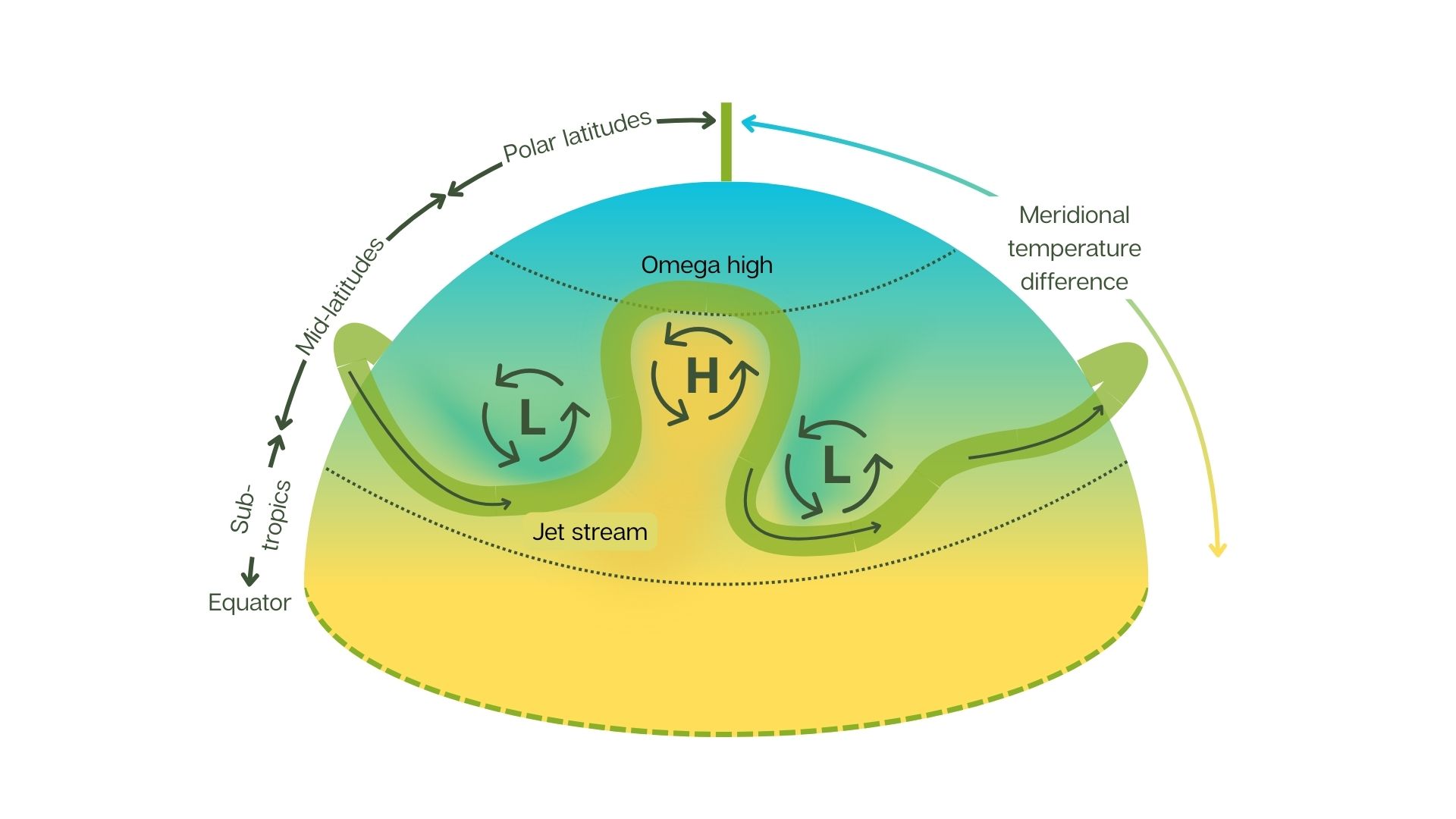
Figure 1: Schematic of an omega blocking high in the mid-latitudes. The jet stream (green band) loops poleward, forming an area of high pressure (labelled H) between two areas of low pressure (labelled L) to the east and west. The high pressure system is typically associated with warmer surface temperatures.

Land–atmosphere feedback intensifies droughts

Once drought begins, several processes can act to reinforce and prolong dry conditions.

Dry soils limit evaporation and evapotranspiration from vegetation (Figure 2). With less moisture returned to the atmosphere, cloud formation becomes less likely, further reducing rainfall. At the same time, dry land surfaces heat more efficiently, leading to higher surface temperatures. This additional heat can increase evaporation from soils, vegetation and water bodies, intensifying drought conditions (Osman, 2026).

Together, these land-atmosphere feedbacks mean that drought can become self-reinforcing, particularly during warm seasons.

Illustration showing a reinforcing drought feedback loop. Dry soils reduce evaporation and evapotranspiration, meaning less moisture returns to the atmosphere, so clouds and rainfall are less likely. Drier land heats more efficiently, intensifying dry conditions and further drying the soil.

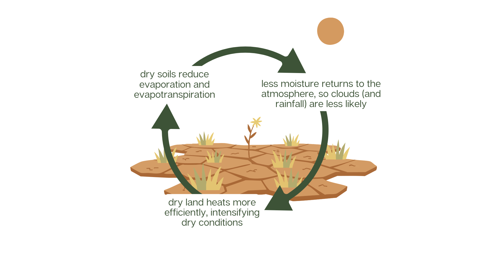
Figure 2: Schematic of a land-atmosphere reinforcing drought feedback loop.

Implications for drought risk and resilience

Drought rarely occurs in isolation. It often causes heatwaves, wildfires and food and water insecurity, with impacts that accumulate over a prolonged period. Because of the complexities of land, vegetation and atmospheric feedbacks, drought remains challenging to forecast and manage.

Improving understanding of atmospheric drivers, land–atmosphere feedbacks and human influences is critical for strengthening drought modelling, monitoring, and early action. As climate change continues to influence the global water cycle, this understanding becomes increasingly important for managing risk across sectors and regions.

References

Osman, M., Zaitchik, B., Lawston-Parker, P., Santanello, J., Anderson, M. (2026). The Interplay of Vegetation and Land–Atmosphere Feedbacks in Flash Drought Prediction. Journal of Hydrometeorology, 27(3), 307–323. [Online]. Available here. [Accessed 2 March 2026].

Richardson (2020). Understanding and quantifying extreme precipitation events in South Asia, Part I –Understanding climate drivers through case studies. CARISSA Activity 4: Climate services for the water and hydropower sectors in South Asia. [Online]. Available here. [Accessed 24 February 2026].

Seneviratne, S.I., X. Zhang, M. Adnan, W. Badi, C. Dereczynski, A. Di Luca, S. Ghosh, I. Iskandar, J. Kossin, S. Lewis, F. Otto, I. Pinto, M. Satoh, S.M. Vicente-Serrano, M. Wehner, and B. Zhou, 2021: Weather and Climate Extreme Events in a Changing Climate. In Climate Change 2021: The Physical Science Basis. Contribution of Working Group I to the Sixth Assessment Report of the Intergovernmental Panel on Climate Change [Masson-Delmotte, V., P. Zhai, A. Pirani, S.L. Connors, C. Péan, S. Berger, N. Caud, Y. Chen, L. Goldfarb, M.I. Gomis, M. Huang, K. Leitzell, E. Lonnoy, J.B.R. Matthews, T.K. Maycock, T. Waterfield, O. Yelekçi, R. Yu, and B. Zhou (eds.)]. Cambridge University Press, Cambridge, United Kingdom and New York, NY, USA, pp. 1513–1766, doi: 10.1017/9781009157896.013. [Online]. Available here. [Accessed 23 February 2026].

WHO (2023). El Niño Southern Oscillation (ENSO). [Online]. Available here. [Accessed 2 March 2026].

INSIGHTS​

Other articles​

Discover more about the challenges and solutions shaping resilience and sustainable development across the globe.

Input your search keywords and press enter.