Each year, tropical cyclones affect millions of people across Asia, Africa, the Pacific, and the Americas, bringing destructive winds, storm surge, and flooding. Understanding how they form and change in a warming climate is critical for resilience. In this article, JBA Climate Scientist Jack Giddings explores the science behind tropical cyclones and the risks they pose worldwide.
Ready to discuss your next project? Contact our team today.
Tropical cyclones are the most powerful weather systems on Earth. When they make landfall, they are at their most destructive – not only from intense winds, but also from extensive flooding caused by storm surge and extreme rainfall. These hazards combine to drive the majority of damage and fatalities.
The formation and behaviour of tropical cyclones are shaped by warm ocean waters, atmospheric circulation, and complex feedback processes that allow them to intensify rapidly. Understanding how they develop, move, and evolve in a warming climate is critical for anticipating impacts, strengthening early warning systems, and building long-term resilience. This article explores the science behind tropical cyclones and the risks they pose worldwide.
Several key conditions are required for a tropical cyclone to form. Warm ocean waters – at or above 27°C – provide the essential fuel, releasing vast amounts of heat and moisture into the atmosphere (Met Office, 2025a). As winds move over these warm surfaces, the air rises, cools, and condenses, driving convection and the formation of storm clouds.
Low vertical wind shear is another requirement. If wind speeds and directions vary little with height, convection can grow vertically, allowing storm clouds to grow taller and strengthen (Met Office, 2025a).
A lesser known but equally important requirement is the Coriolis effect – the apparent force created by Earth’s rotation that deflects winds to the right in the northern hemisphere and to the left in the southern hemisphere. This spin helps tropical cyclones organise their convection, developing their characteristic rotation and structure. Near the Equator, however, the Coriolis effect is too weak to generate this rotation, which is why tropical cyclones never form at the Equator or cross it.
Even when favourable conditions are in place, a pre-existing weather disturbance is usually needed to initiate cyclone formation. These disturbances provide the initial cluster of thunderstorms or area of low pressure that can then organise and intensify once the ocean and atmospheric conditions are right. Their nature varies by ocean basin:
Atlantic: Tropical cyclones often begin from African Easterly Waves – ripples of low pressure that travel westward from Africa across the Atlantic Ocean.
Indian and Pacific Oceans: Tropical cyclones here are commonly initiated by large clusters of thunderstorms, sometimes called superclusters, which provide the initial focus of rising air.
Bay of Bengal: In this region, depressions in the monsoon trough (elongated areas of low pressure that form during the summer monsoon) frequently act as the starting point for storms.
Once formed, tropical cyclones are known by different names around the world (Figure 1). In the Atlantic and eastern Pacific, they are called hurricanes; in the western Pacific, they are known as typhoons; and in the Indian Ocean and South Pacific, they retain the name tropical cyclones. Despite these regional variations, the underlying physical processes are the same.

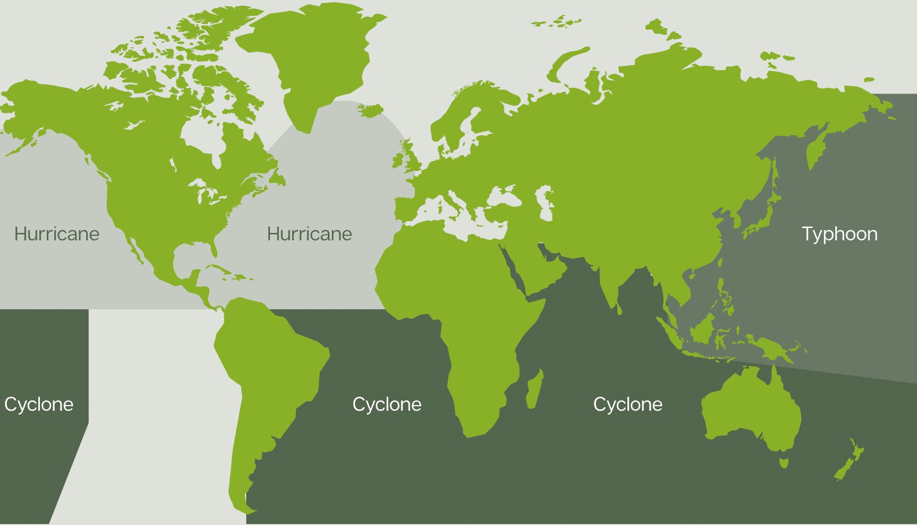
Figure 1: Tropical cyclone naming conventions around the world.
Tropical cyclone intensification is still an area of active research. One mechanism that helps explain this process is the Wind-Induced Surface Heat Exchange (WISHE) theory. As convective storms release latent heat, they warm the mid-troposphere and lower surface pressure, intensifying winds. Stronger winds then draw up more heat and moisture into the atmosphere, fuelling further convection. This positive feedback loop can organise clusters of thunderstorms into a tropical depression, which can then strengthen into a mature tropical cyclone once wind speeds exceed a certain threshold.
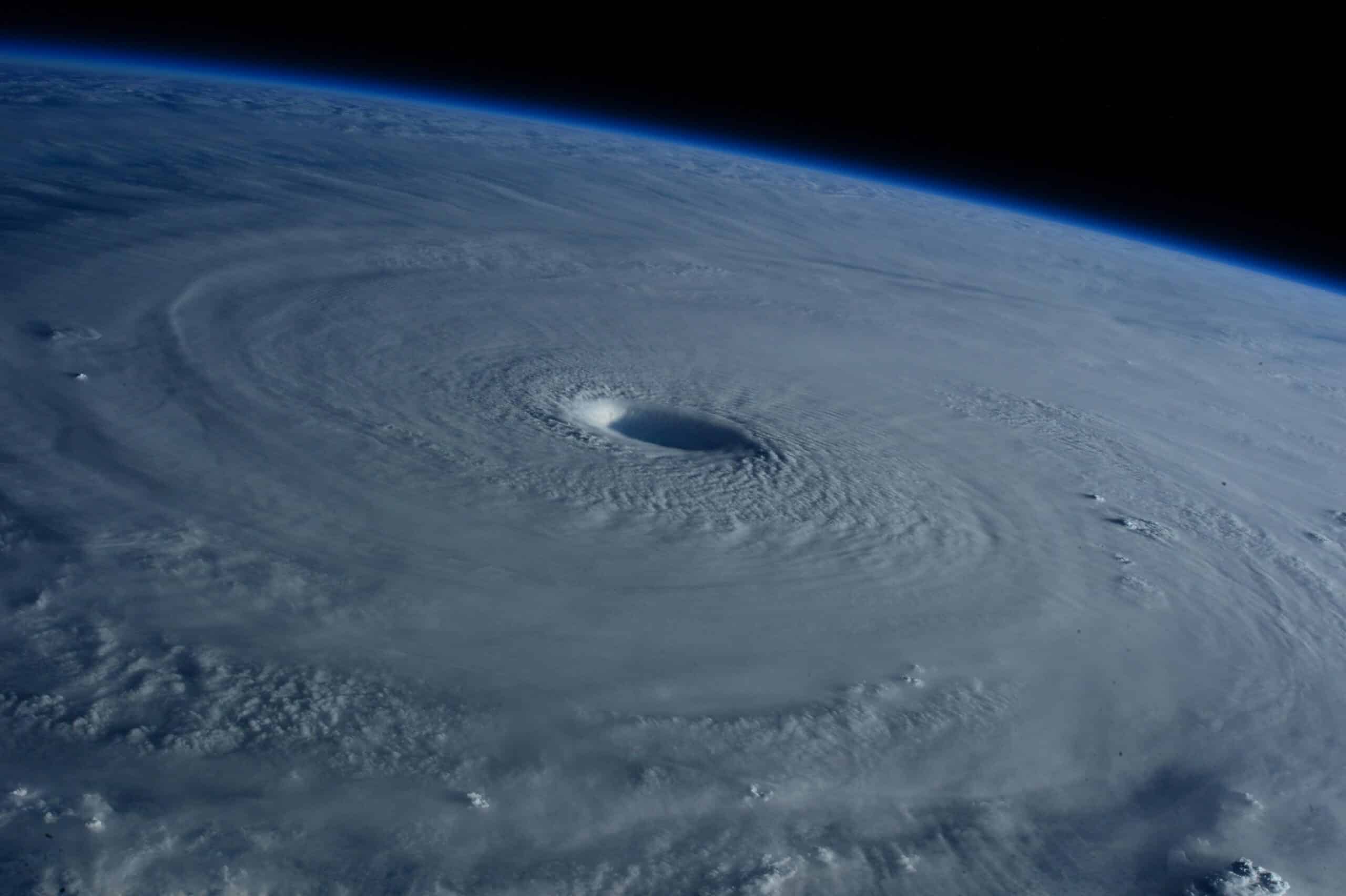
As the tropical cyclone strengthens, it develops spiralling bands of thunderstorms and a central ‘eye’, surrounded by intense thunderstorms of the eyewall (Figure 2). Over time, cyclones may undergo eyewall replacement cycles, where a new eyewall forms and replaces the original, temporarily weakening maximum wind speeds but expanding the tropical cyclone’s overall size.

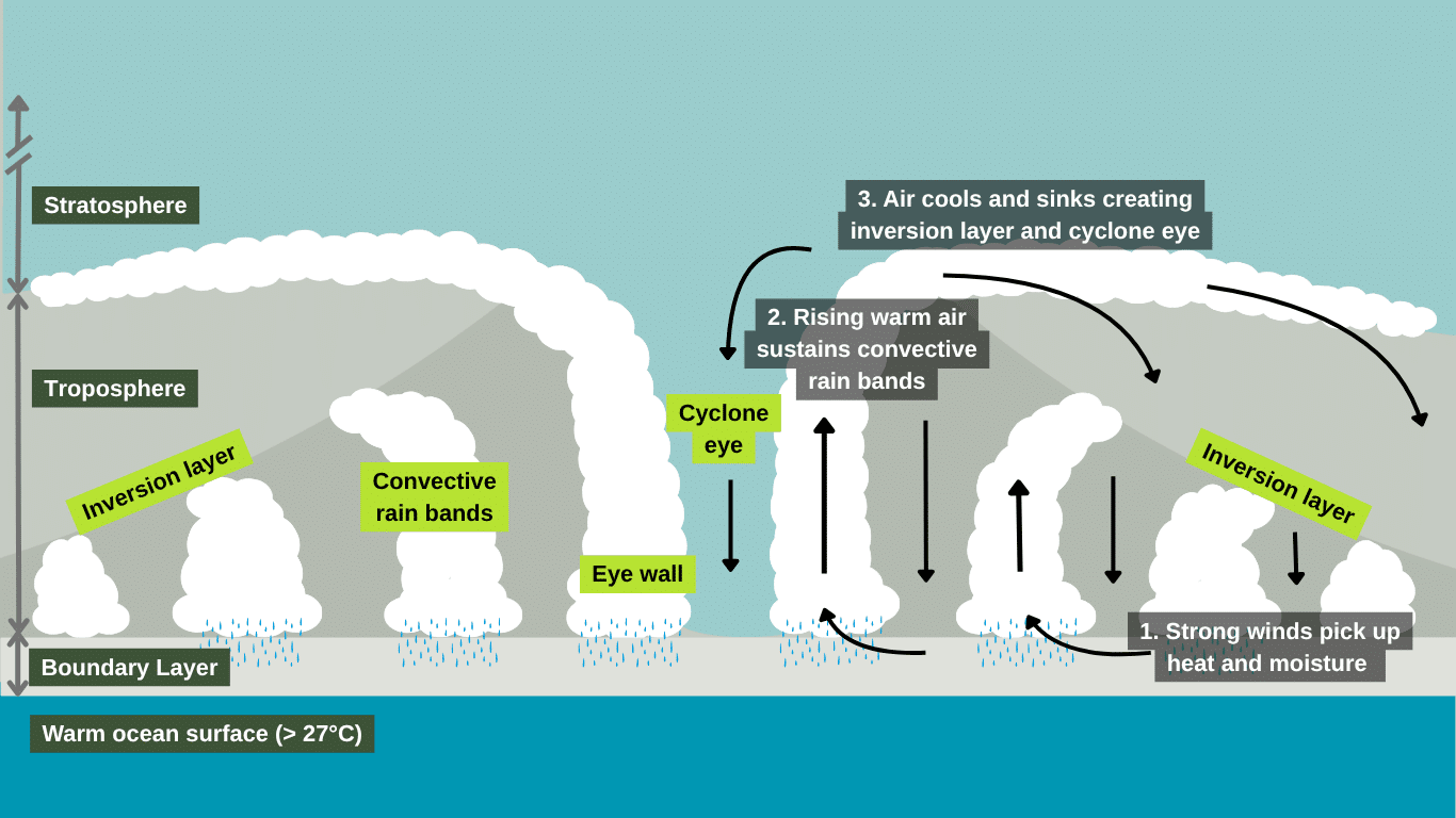
Figure 2: Illustration of the formation and structure of a tropical cyclone.
While these internal processes shape a tropical cyclone’s structure and intensity, its movement is controlled by larger-scale atmospheric patterns. As these systems develop, their track is shaped by prevailing winds and is also influenced by the beta effect – the change in the Coriolis force with latitude. Because the Coriolis force increases with distance from the Equator, the northern side of a storm in the Northern Hemisphere is deflected more strongly than the southern side. This imbalance produces a gradual poleward and westward drift, which explains why tropical cyclones follow curved trajectories – moving westward at low latitudes before turning poleward and eastward in the mid-latitudes (AMS, 2024).
As tropical cyclones move inland, they usually weaken rapidly without their ocean heat source. Yet under certain conditions, the landscape itself can sustain or even re-energise these systems. One rare but significant example is the ‘brown ocean effect’.
When the ground is saturated and humidity levels are high, the land can mimic ocean-like conditions, providing enough moisture and heat flux to maintain convection. A notable example is Tropical Storm Bill (2015). Following a record-wet May in Texas and Oklahoma, saturated soils combined with summer heat to create a highly humid environment. As Bill moved inland, it unexpectedly re-intensified, compounding rainfall totals and worsening floods in the region (Met Office, 2025b).
Tropical cyclones are becoming more intense and unpredictable. Increasing sea surface temperatures allow for rapid cyclone intensification and higher sustained peak strengths. These higher sea surface temperatures also linger well after the summer season, extending the seasonal window for storm formation.
Hurricane Milton in 2024 intensified from a tropical storm to a Category 5 hurricane in just 24 hours over the Gulf of Mexico. Sea surface temperatures were exceptionally high – above 30°C – fuelling its rapid growth. Attribution studies suggest that storms of Milton’s intensity are already around 40% more likely than they were in a cooler climate (WWA, 2024).
In Southeast Africa, Tropical Storm Ana made landfall in Madagascar, Mozambique, and Malawi in January 2022, leading to severe flooding that affected over a million people. Just weeks later, Tropical Cyclone Batsirai struck, followed by three weaker storms – Dumako, Emnati, and Gombe – which further exacerbated the flooding and humanitarian impacts. Attribution studies suggest that the excessive rainfall from these cyclones was made more likely in today’s warmer climate than it would have been in a cooler one (WWA, 2022).
However, the exact increase in likelihood remains uncertain due to limited long-term rainfall and river gauge data in the region. Expanding these observation networks is essential, not only to quantify climate impacts more accurately, but also to strengthen early warning systems that support humanitarian response (Imperial, 2022).

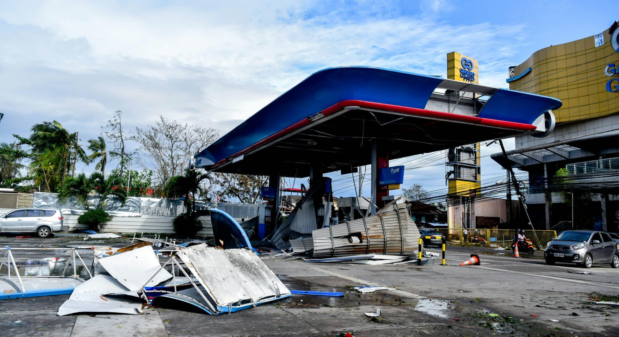
Damaged fuel station following Super Typhoon Rai (Odette), Philippines, 2022.
For communities across tropical cyclone-prone regions, the threat from stronger storms is profound. More intense tropical cyclones mean greater exposure to flooding, and cascading impacts on infrastructure, economies, and livelihoods. Anticipating these risks requires both global-scale climate insights and high-resolution flood hazard data.
At JBA, we bring these perspectives together. Our Global Flood Maps reveal where people and assets are most at risk. Our Global Flood Models quantify potential impacts, supporting investment decisions and long-term planning. And with Flood Foresight, our flood forecasting and monitoring system, organisations can anticipate flooding as it develops and act quickly to protect lives and livelihoods.
By combining science, data, and expertise, we provide an integrated picture of flood risk – from future scenarios to imminent threats. This joined-up approach strengthens early warning, supports anticipatory action, and helps build resilience in the face of one of the planet’s most powerful natural forces.
American Meteorological Society, 2024. Beta drift. [Online] [Accessed 19 August 2025].
Climate Central, 2024. Analysis: Ocean temperatures warmed by climate change provided fuel for Hurricane Milton’s extreme rapid intensification. [Online]. [Accessed 19 August 2025].
Imperial, 2022. Climate change increased extreme rainfall in Southeast Africa storms. [Online]. [Accessed 15 September 2025].
Met Office, 2025a. Development of tropical cyclones. [Online]. [Accessed 19 August 2025].
Met Office, 2025b. Brown ocean effect. [Online]. [Accessed 19 August 2025].
WWA, 2022. Climate change increased rainfall associated with tropical cyclones hitting highly vulnerable communities in Madagascar, Mozambique & Malawi. [Online]. [Accessed 15 September 2025].
WWA, 2024. Yet another hurricane wetter, windier and more destructive because of climate change – World Weather Attribution. [Online]. [Accessed 19 August 2025].
Ready to discuss your next project? Contact our team today.
Discover more about the challenges and solutions shaping resilience and sustainable development across the globe.