In the spring of 2026, intense rainfall during Kenya’s long rains led to rapid rises in river levels and localised flash flooding in Nairobi, as urban drainage systems were overwhelmed. Here we explore why flood risk is concentrated in the city, and what the floods reveal about urban vulnerability and resilience.
Ready to discuss your next project? Contact our team today.
In March 2026, intense rainfall during the long rains season triggered localised flash floods across parts of Kenya, with Nairobi the hardest hit. Rapid surface runoff overwhelmed urban drainage systems, while intense rainfall across the catchment caused water levels in the Nairobi and Ngong Rivers to rise quickly and breach their banks, flooding homes and businesses and damaging critical infrastructure
But what does this event reveal about flood risk in Nairobi? The sections that follow examine the factors that make the city particularly vulnerable to flooding, the meteorological conditions that contributed to the March 2026 events, the resulting impacts, and the lessons for building urban resilience.
Nairobi’s flood risk is shaped by a combination of physical geography and rapid urbanisation. The city sits on a floodplain with several rivers and streams flowing through it. Its name comes from the Maasai phrase “Enkare Nyrobi” meaning “cool water”, referring to the swampy landscape on which the city was originally founded on (Nairobi City Council, 2026).
This landscape makes the city naturally prone to flooding, particularly during periods of intense rainfall. High-intensity storms rapidly lead to surface runoff due to extensive impermeable surfaces and limited drainage capacity. Water accumulates quickly in low-lying areas, particularly where drainage systems are undersized or blocked by waste, meaning even short periods of intense rainfall can lead to severe flooding within hours.
Rapid urban growth has significantly increased this vulnerability. In the last century, Nairobi’s population has grown from 100,000 residents to over 4.5 million, while drainage, sewage and waste management systems have not kept pace (BBC, 2024). Fewer than half the residents are connected to formal sewage networks, resulting in widespread reliance on informal drainage channels that are often blocked with solid waste and become easily overwhelmed during heavy rainfall (BBC, 2024).
Exposure has been further amplified by unregulated development in flood-prone areas, including riverbanks and wetlands. Informal settlements in low-lying areas are particularly at risk, with limited protective infrastructure and restricted access to services, intensifying the impacts of flooding when it occurs.

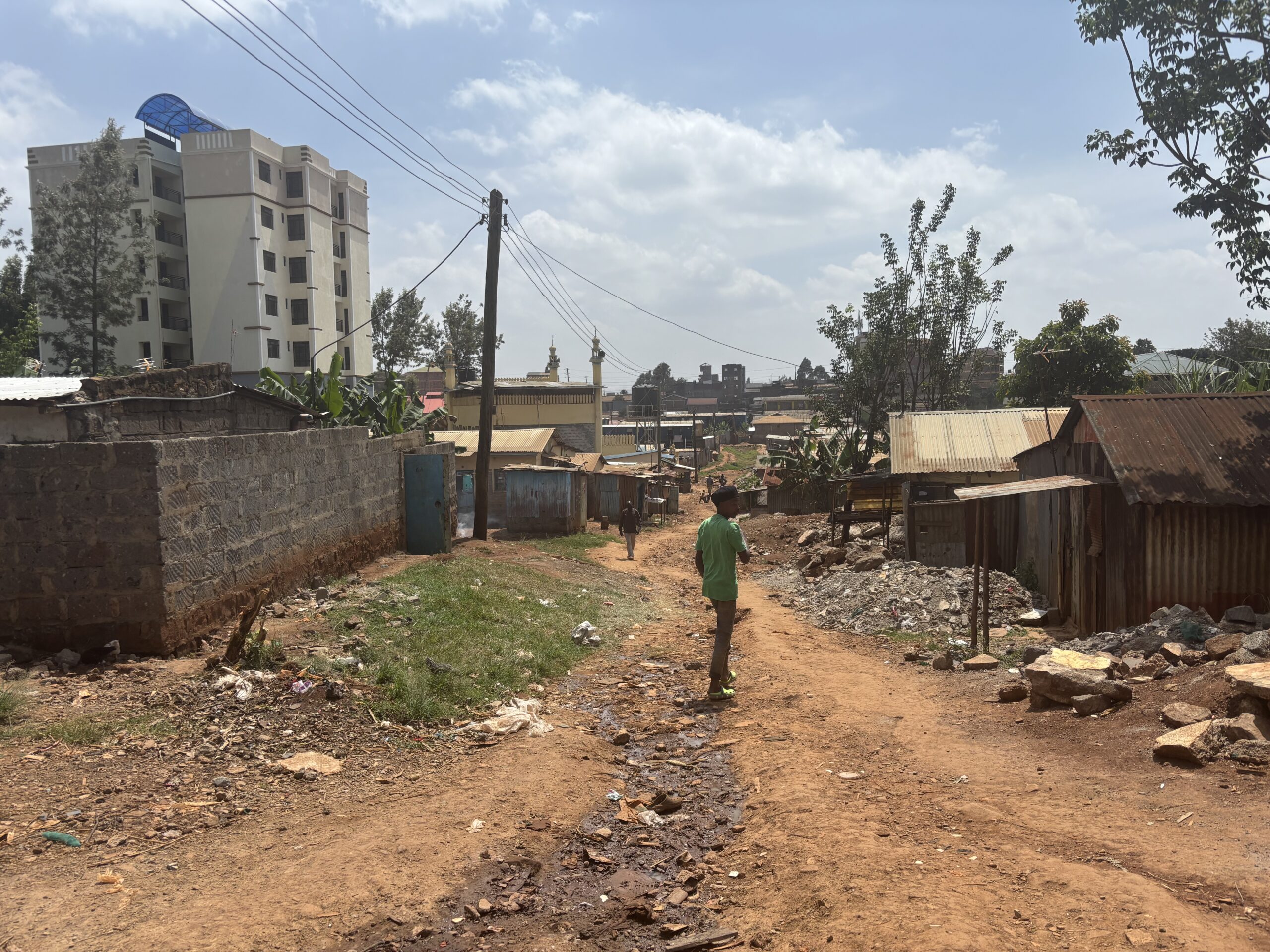
Informal housing, Nairobi.
In early March 2026, a series of localised, intense rainfall events led to rapid river level rises and flash flooding, particularly in Nairobi’s low-lying urban areas (Figure 1). Flooding was reported on 6 March and again on 14 March, with satellite estimates indicating around 200 mm of rainfall between 1 and 8 March (ReliefWeb, 2026a).
These heavy rains occurred during Kenya’s long rains season (March-May). The timing, intensity and movement of the long rains are strongly influenced by the Intertropical Convergence Zone (ITCZ), a region of high convective activity that shifts northwards across the Equator at this time of year. As the ITCZ passes through the region, it helps drive the seasonal rainfall patterns.
Rainfall across East Africa has generally been spatially and temporally sporadic — arriving in short, intense bursts separated by drier spells rather than as sustained seasonal rainfall — contributing to localised flooding in urban areas such as Nairobi (Figure 1). Four weeks of this locally above-average rainfall has led to soil over-saturation, meaning any additional rainfall pools at the surface exacerbating the flooding and landslides in the region (CPC NCEP, 2026).

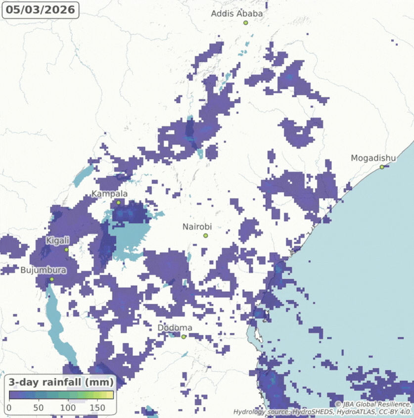
Figure 1: Animation of 3-hourly satellite-derived rainfall estimates (in mm) from NASA GPM across East Africa between 5 to 16 March 2026.
The March 2026 floods in central-western Kenya resulted in loss of life, widespread disruption and extensive damage to homes, infrastructure and livelihoods. Between 6 and 9 March, 42 fatalities were reported nationally, including 26 in Nairobi (Aljazeera, 2026). As heavy rainfall continued, the death toll rose to 66 between 9 and 15 March, with 33 fatalities in Nairobi (ReliefWeb, 2026b).
Flooding affected multiple neighbourhoods across Nairobi, including Parklands and the Central Business District, as emergency responders assisted stranded residents (Kenya Red Cross Society, 2026). The Nairobi River burst its banks, inundating homes, displacing residents and sweeping away vehicles in low-lying neighbourhoods and informal settlements. Flooded roads and disruption at Nairobi airport compounded economic impacts and restricted movement (AfricaNews, 2026; Aljazeera, 2026).
Impacts varied across the city. Reports identified poor drainage and the obstruction of waterways and river channels, linked to unregulated development, as key factors exacerbating flood impacts in some areas. In contrast, other low-lying parts of the city with appropriate flood prevention infrastructure reportedly did not experience flooding, underlining the role of local infrastructure and planning in shaping impacts (BBC, 2026).
The impacts of the March 2026 flooding were not confined to Kenya. In neighbouring Ethiopia, severe flooding and landslides resulted in over 100 fatalities and significant agricultural losses indicating a broader regional humanitarian impact associated with the same period of heavy rainfall (BBC, 2026; Aljazeera, 2026).
The flooding occurred alongside an ongoing drought affecting other parts of Kenya and the wider Horn of Africa. Rainfall between October and December 2025 was exceptionally low across much of the eastern Horn of Africa, including eastern Kenya, southern Somalia and parts of Ethiopia. Those deficits persisted into early 2026.
As a result, water resources remained under pressure as the wet season began. The Kenya Red Cross Society estimates that 3.3 million people need food assistance, with 1.5 million in urgent need of water (Kenya Red Cross Society, 2026).
Flooding is a recurrent hazard in Kenya. Between 1964 and 2004, Kenya experienced 17 major flood events, each affecting around 70,000 people (Parry et al, 2012). More recent events illustrate the scale and frequency of impacts, especially in Nairobi and surrounding counties.
In 2024, excessive rainfall from March to May caused severe floods and landslides across Kenya and neighbouring countries of Tanzania and Burundi. In Kenya, floods across Nairobi, Kiambu and Machakos, impacted over 100,000 people and resulted in more than 200 fatalities (BBC, 2024; CNN, 2024). In Nairobi, the floods led to evacuations as rivers and sewage systems overflowed. The main railways into the city were inundated resulting in disruption to commuter train services (CNN, 2024).
A similar pattern occurred in March–May 2018, when intense rainfall affected Kilifi, Nairobi, Machakos, and Taita Taveta. The floods displaced around 300,000 people, caused over 180 fatalities, submerged 8,700 hectares of farmland and resulted in the loss of 19,000 livestock. Critical infrastructure and transport networks across Nairobi were also cut off (Kilavi et al., 2018).
These events underline a persistent pattern of high-impact flooding during the long rains season, with Nairobi consistently among the most affected urban centres.

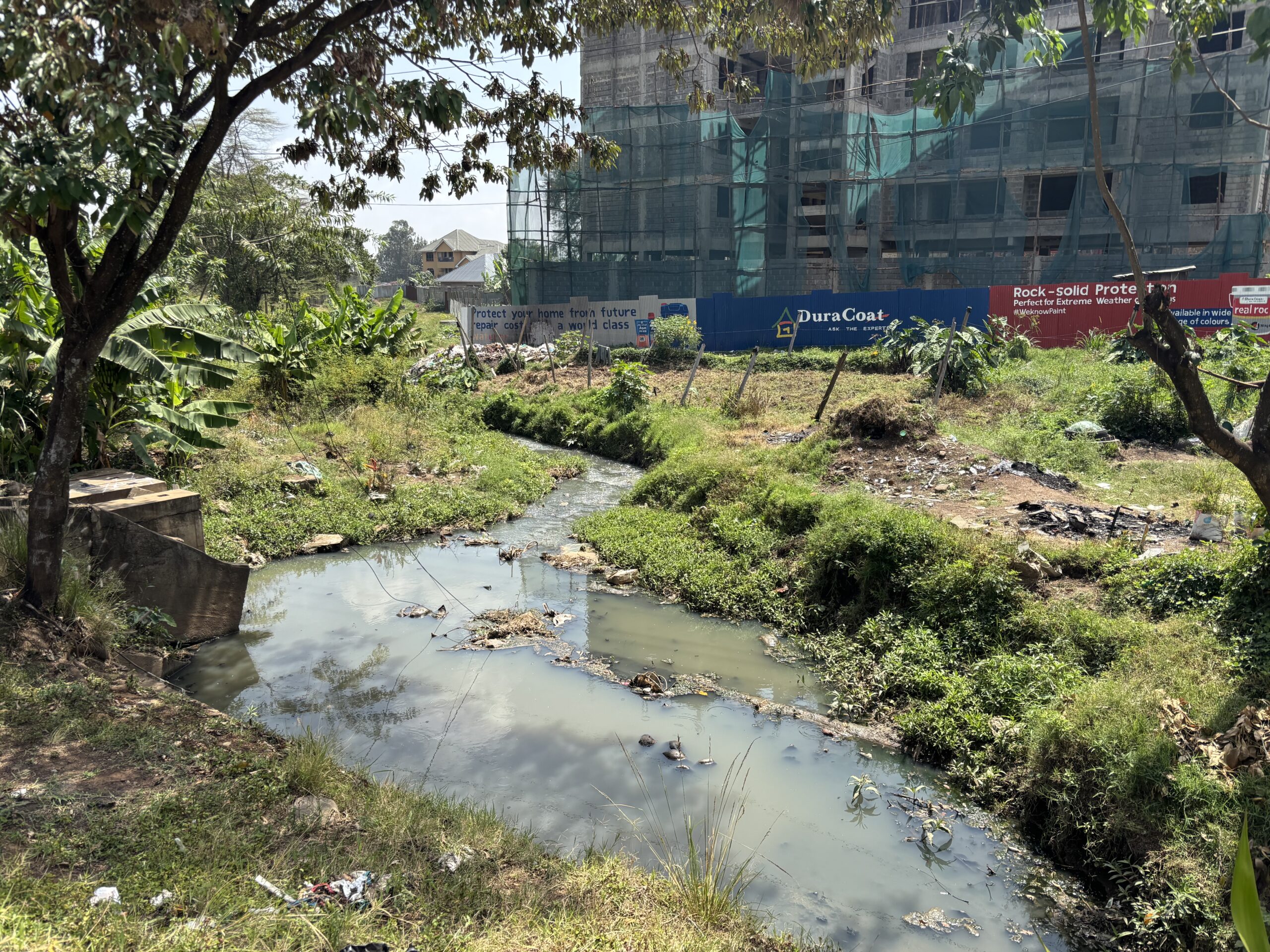
Urban drainage channel and surrounding development, Nairobi
The March 2026 floods highlight the need to strengthen urban flood resilience in rapidly growing cities like Nairobi. This is done most effectively through implementation of holistic strategies that combine a range of measures, including:
As climate variability increases, the combination of rapid urbanization and more intense rainfall events is likely to amplify flood risk. Addressing this challenge requires coordinated action across infrastructure, planning, and governance to build long-term urban resilience.
AfricaNews, 2026. Kenya faces deadly flooding with at least 108 people killed. [Online]. Available here. [Accessed 2 April 2026].
Aljazeera, 2026. At least 42 people killed in days of floods across Kenya. [Online]. Available here. [Accessed 16 March 2026].
BBC, 2026. Severe flooding kills 66 in Kenya, as heavy rains continue. [Online]. Available here. [Accessed 16 March 2026].
BBC, 2024. Kenya floods: What a deluge reveals about Nairobi’s vulnerability. [Online]. Available here. [Accessed 23 March 2026].
CNN, 2024. At least 32 dead as flash floods sweep through half of Kenya. [Online]. Available here. [Accessed 23 March 2026].
CPC NCEP, 2026. Climate Prediction Center’s Africa Hazards Outlook For DOS / FEWS-NET. [Online]. Available here. [Accessed 31 March 2026].
Kenya Red Cross Society, 2026. Drought Crisis 2026. [Online]. Available here. [Accessed 17 March 2026]
Kilavi, M., MacLeod, D., Ambani, M., Robbins, J., Dankers, R., Graham, R., Titley, H., Salih, A. A. M., & Todd, M. C., 2018. Extreme Rainfall and Flooding over Central Kenya Including Nairobi City during the Long-Rains Season 2018: Causes, Predictability, and Potential for Early Warning and Actions. Atmosphere, 9(12), 472. [Online]. Available here. [Accessed 23 March 2026].
Nairobi City Council, 2026. History of Nairobi. [Online]. Available here [https://nairobi.go.ke/history]. Accessed 31 March 2026].
Parry, J., Echeverria, D., Dekens, J., Maitima, J., 2012. Climate Risks, Vulnerability and Governance in Kenya: A Review. UNDP, New York, NY, USA. 78pp. [Online]. Available here. [Accessed 23 March 2026].
ReliefWeb, 2026a. Kenya | Severe weather and flash floods – DG ECHO Daily Map | 10/03/2026. [Online]. Available here. [Accessed 31 March 2026].
ReliefWeb, 2026b. Kenya – Floods, update (NOAA-CPC, media) (ECHO Daily Flash of 16 March 2026). [Online]. Available here. [Accessed 17 March 2026].
Ready to discuss your next project? Contact our team today.
Discover more about the challenges and solutions shaping resilience and sustainable development across the globe.