Articles

El Niño 2026: what’s coming and why it matters

El Niño is a recurring climate pattern that shapes weather conditions around the world. With a new event likely to develop in 2026, JBA Climate Scientist Dr Jack Giddings explores how El Niño forms, how it influences temperature and rainfall patterns, and why it matters for understanding and managing climate risk.

Tractor working in a dry agricultural field with visible dust in the air, illustrating farming conditions under heat and low rainfall

Contents:

El Niño is one of the most dominant processes influencing global climate variability. It reshapes rainfall and temperature patterns across multiple regions and amplifies climate risks such as floods, droughts and heat across continents.

In 2026, signals in the central and eastern Pacific are shifting again. After a period of neutral conditions, warming sea surface temperatures are increasing the likelihood of El Niño developing through the middle of 2026, with some forecasts indicating the potential for a very strong or “super El Niño” (NCEP, 2026; Columbia Climate School, 2026).

This transition reflects a broader reorganisation of the ocean-atmosphere system. As heat builds in the central and eastern Pacific, atmospheric circulation patterns begin to change, influencing how weather systems develop and where rainfall falls around the globe.

Understanding how this event is developing, and how it could shape regional climate patterns in the months ahead, supports earlier and more informed planning.

What is El Niño?

El Niño is the warm phase of the El Niño-Southern Oscillation (ENSO), a natural climate pattern centred in the Equatorial Pacific Ocean. It typically occurs every two to seven years and lasts around nine to twelve months.

During an El Niño event, sea surface temperatures in the central and eastern Pacific become warmer than average (Figure 1). Easterly trade winds weaken, and in some cases reverse, allowing warm water to shift eastward (NASA, 2026).

This redistribution of heat alters the Walker Circulation, an east-west circulation along the Equator. Convective activity increases over the central and eastern Pacific, bringing above average rainfall to the region. At the same time, descending cooler air surpresses convection across the Maritime Continent, leading to below average rainfall.

These changes influence weather patterns far beyond the Pacific. El Niño redistributes atmospheric heat and moisture, affecting rainfall patterns, temperature extremes and storm activity across multiple regions worldwide.

Figure 1: Animation of the different Walker Circulation patterns under neutral ENSO and El Niño conditions across the Equatorial Pacific. Global elevation data sourced from GLOBE Task Team and others, 1999.

What is happening now?

As of late May 2026, ENSO conditions remain close to neutral but evolving. Sea surface temperatures across the central and eastern Pacific are increasing above average in the Niño 3.4 region – an area commonly monitored by climatologists between 120°W to 170°W (NCEP, 2026).

This warming may have been initiated by westerly wind bursts from enhanced tropical cyclone activity near the Equator earlier in the year, triggering intense subsurface warming off the east coast of South America (Climate Central, 2026; Phys, 2026).

El Niño is commonly confirmed when average sea surface temperatures in the Niño 3.4 region remain about 0.5°C above the long-term average for several consecutive months. However, definitions vary between agencies, with some also considering coupled ocean–atmosphere conditions. Despite these differences, model forecasts consistently indicate that El Niño conditions are likely to develop between June and August (Figure 2).

The average signal from seasonal models suggests a strong probability that warming will persist through the rest of the year, with sea surface temperatures peaking above 2°C (Figure 2; solid red line).

Although forecast models show broad agreement that El Niño is likely to develop, uncertainty remains around how strong the event will become. This largely depends on how the atmosphere responds to the evolving ocean conditions, and whether reinforcing feedback strengthens the warming across the central and eastern Pacific.

At the same time, uncertainty remains an inherent part of seasonal forecasting, and not all projected El Niño events fully materialise. For example, forecasts issued during spring 2017 pointed toward a strong likelihood of El Niño development later that year, yet conditions evolved into a La Niña event (NCEP, 2017).

What is clear is that the surface ocean conditions are evolving, and early signals are already influencing seasonal outlooks in several regions.

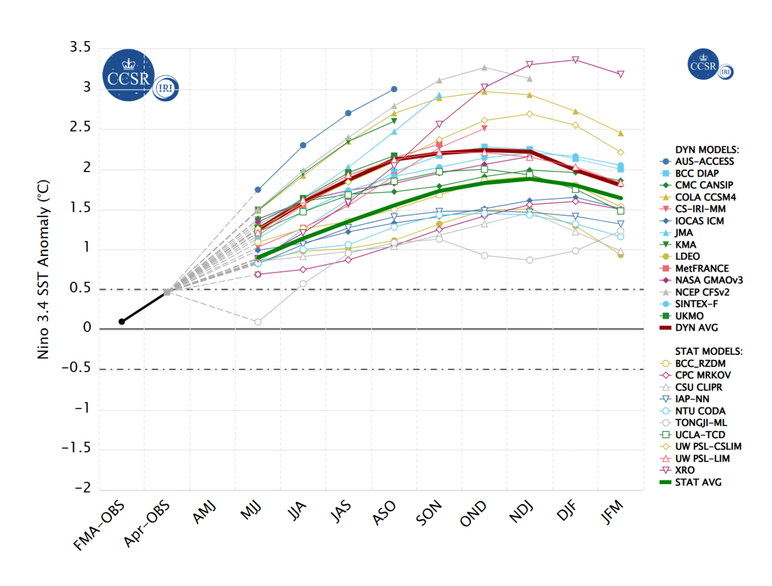
Figure 2: Model predictions of ENSO from May 2026. Sea surface temperature anomaly forecasts in the Niño 3.4 region from major model agencies. The dynamic multi-model mean is represented by the solid red line, and the statistical multi-model mean is represented by the solid green line. Anomalies above +0.5°C indicate an El Niño event, whereas anomalies below -0.5°C indicate an La Niña event. Sourced from Columbia Climate School, 2026.

How El Niño reshapes regional climate patterns

El Niño alters the distribution of rainfall (Figure 3) and temperature (Figure 4) by shifting large-scale atmospheric circulation. While these shifts tend to produce consistent regional patterns, no two El Niño events are exactly the same.

Figure 3: Global map showing El Niño precipitation impact. Each El Niño event is different and changes to precipitation vary between seasons. Sourced from BBC 2026.

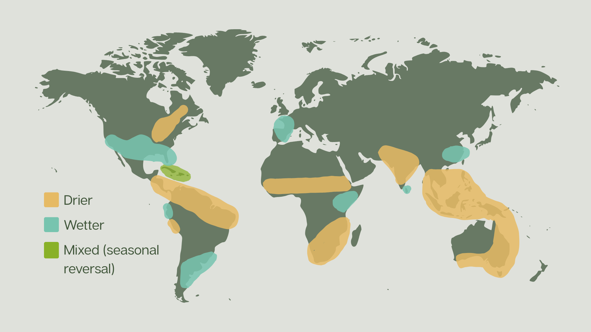
Figure 3: El Niño precipitation impact. Each El Niño event is different and changes to precipitation vary between seasons. Adapted from BBC News 2026.

Figure 4: Global map showing El Niño temperature impact. Each El Niño event is different and changes to precipitation vary between seasons. Sourced from BBC 2026.

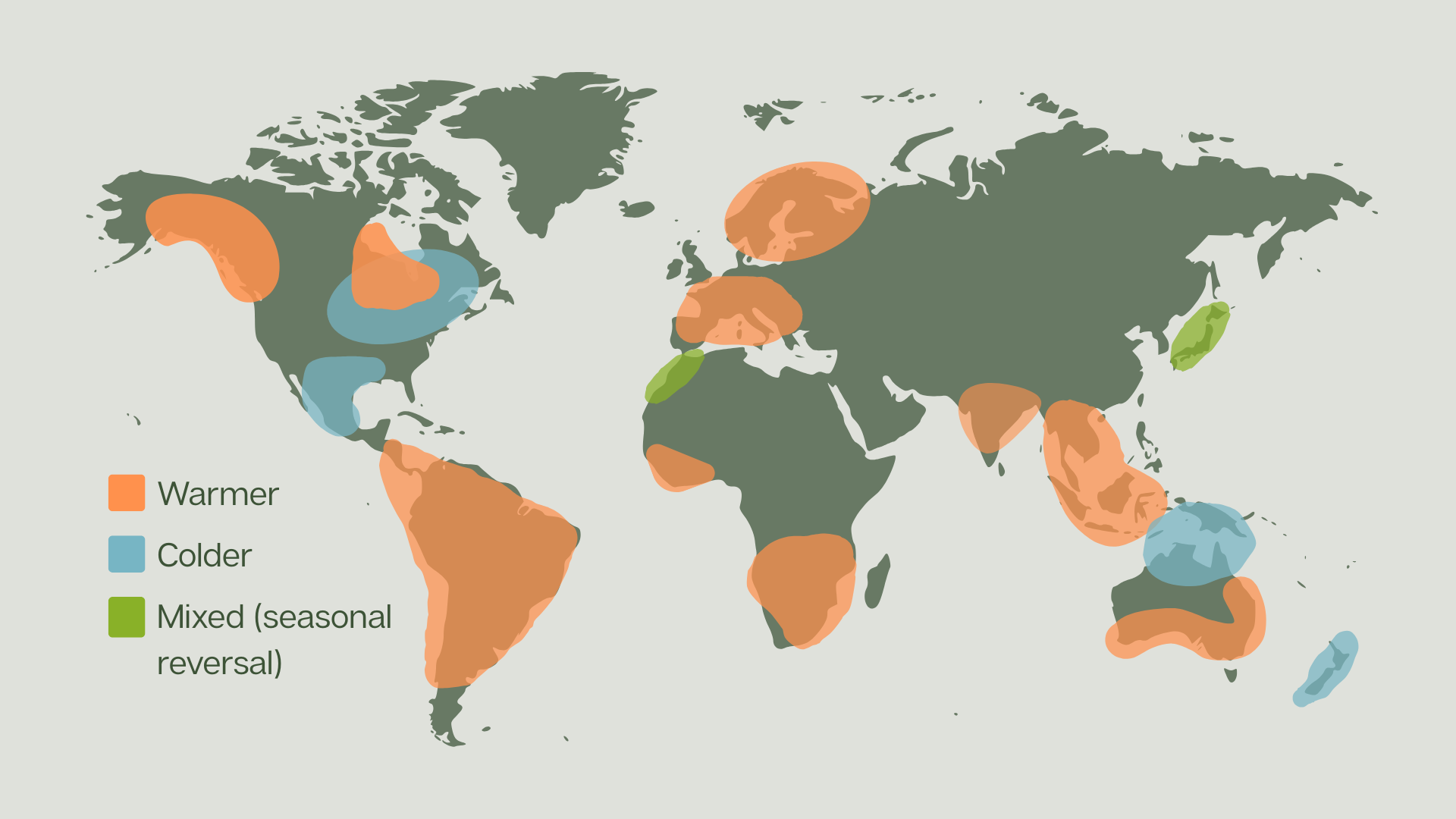
Figure 4: El Niño temperature impact. Each El Niño event is different and changes to precipitation vary between seasons. Adapted from BBC News 2026.

Southeast Asia and the Pacific Island Countries

Across Southeast Asia and western Pacific Islands, El Niño is typically associated with hotter and drier conditions. Suppressed convective activity over Maritime Continent can weaken monsoon systems and extend dry periods. Conversely, central Pacific Islands often experience wetter than average conditions (WHO, 2023).

For 2026, seasonal outlooks already indicate a risk of below-average rainfall and delayed or weakened monsoon activity across Southeast Asia.

Reduced rainfall can place significant pressure on water availability, agriculture and energy systems, particularly in countries where seasonal rainfall plays a central role in food production and supply chains (UNDRR, 2026).

Indian Subcontinent and the South Asian monsoon

The South Asian monsoon is influenced by ENSO variability. During El Niño years, the monsoon circulation tends to weaken and reduce seasonal rainfall across parts of the subcontinent.

Early outlooks for 2026 point towards a subdued monsoon, reflecting the developing conditions in the Pacific.

For India, where agriculture and economic productivity are reliant on monsoon performance, slight reductions in seasonal rainfall can have severe consequences. During the 2015-2016 El Niño-driven drought, it was estimated 330 million people were impacted by food shortages (UNICEF, 2026).

The Indian Ocean Dipole (IOD) – a climate pattern defined by differences in sea surface temperatures across the Indian Ocean – can also influence monsoon rainfall. It is estimated that agricultural growth falls by around 2.4% during El Niño and neutral IOD conditions (Reserve Bank of India, 2023).

East, Southern Africa and the Sahel

In Southern Africa and the Sahel, El Niño is commonly associated with drier conditions and increased drought risk, particularly during the main growing season (WHO, 2023; OCHA, 2024). Impacts in East Africa are more variable, with rainfall patterns influenced by the timing and evolution of the event. Earlier El Niño development can reduce rainfall between June and September. Later El Niño development can enhance rainfall during the October to December short rains season (FEWS NET, 2026).

Previous El Niño conditions have led to severe drought in this region. The 1991-1992 drought in southern Africa affected 100 million people, and the 2020-2023 drought in East Africa left millions experiencing acute food insecurity (WHO, 2023).

The Americas

El Niño often brings increased rainfall to coastal regions of Peru and Ecuador, while northern Brazil experiences decreased rainfall (WHO, 2023).

Further north, shifts in the Polar jet stream influence seasonal weather patterns across Central and North America. Regions such as Peru, Mexico and southwestern United States may experience wetter conditions during the winter months, while northern Brazil and northeastern United States may experience drier conditions (NASA, 2026).

Historically, El Niño conditions tend to suppress Atlantic hurricane activity through increased vertical wind shear, while supporting greater tropical cyclone activity across parts of the eastern and central Pacific (NASA, 2026).

Impacts on agriculture and livelihoods vary geographically. El Niño conditions can favour improved soybean yields in the US and Argentina, while reducing coffee yields in Brazil (UNDRR, 2026). Fishing industries along the Pacific coast of South American can also be affected due to a reduction of upwelling cool, nutrient-rich waters that sustain marine ecosystems.

Preparedness

The global and varied impact of El Niño means that preparedness cannot follow a single approach. The risks vary by geography, season and exposure, meaning that response strategies must be locally informed and implemented ahead of key agricultural, hydrological and humanitarian decision points.

For governments and humanitarian organisations, this reinforces the importance of anticipatory action. Early warning systems, seasonal outlooks and climate-informed planning can support early interventions, helping to reduce losses and strengthen resilience before impacts escalate.

Recent seasonal forecasts have prompted a number of countries to take anticipatory action, for example:

  • Chad activated anticipatory action measures on 30 April 2026, with a further activation on 9 May, to help protect livelihoods and food security in communities exposed to potential El Niño-driven drought (Anticipation Hub, 2026).
  • The World Food Programme activated an anticipatory action programme in four Central American countries – El Salvador, Guatemala, Honduras and Nicaragua – in response to low seasonal rainfall forecasts and the risk of El Niño intensifying drought conditions. This allows partners to prepare earlier for expected impacts (ReliefWeb, 2026).

Advances in climate science and forecast modelling continue to improve our understanding of ENSO and its global impacts. These improvements strengthen our ability to monitor risks, support preparedness planning and inform earlier action.

In an increasingly climate risk aware world, understanding El Niño is no longer siloed to the Meteorological and Climatological community. It is a critical component of disaster risk reduction, resilience planning and humanitarian preparedness.

References

Anticipation Hub, 2026. From preparedness to activation: partners act to anticipate drought in Chad. [Online] Available here [Accessed 21 May 2026].

BBC News, 2026. What are El Niño and La Niña, and how do they change the weather? [Online]. Available here [Accessed 02 June 2026].

Climate Central, 2026. ‘Twin’ Cyclones Could Jolt Weak El Nino. [Online] Available here [Accessed 20 May 2026].

Columbia Climate School, 2026. ENSO Forecast. [Online] Available here [Accessed 20 May 2026].

FEWS NET, 2026. East Africa Seasonal Monitor May 18, 2026: Highly variable seasonal conditions and developing El Niño signals concerns across East Africa. [Online] Available here [Accessed 20 May 2026].

GLOBE Task Team and others, 1999. The Global Land One-kilometer Base Elevation (GLOBE) Digital Elevation Model, Version 1.0. [Online]. Available here [Accessed 5 December 2025]

NASA, 2026. El Niño: Pacific Wind and Current Changes Bring Warm, Wild Weather. [Online] Available here [Accessed 20 May 2026].

NCEP, 2017. Amplitude-corrected Nino3.4 forecasts. [Online] Available here [Accessed 29 May 2026].

NCEP, 2026. ENSO: Recent Evolution, Current Status and Predictions. [Online] Available here [Accessed 29 May 2026].

OCHA, 2024. Southern Africa: El Niño Regional Humanitarian Overview, September 2024. [Online] Available here [Accessed 20 May 2026].

Phys, 2026. A ‘super El Niño?’ Why it’s too early to forecast one with certainty, but not too soon to prepare. [Online] Available here [Accessed 20 May 2026].

ReliefWeb, 2026. Anticipatory Action ahead of El Niño: WFP’s regional response in the Dry Corridor, Central America (March 2026). [Online] Available here [Accessed 21 May 2026].

Reserve Bank of India, 2023. Weather Events and their Impact on Growth and Inflation in India, RBI Bulletin. [Online] Available here [Accessed 21 May 2026].

UNDRR, 2026. Impacts of an impending “Super” El-Niño on global supply chains. [Online] Available here [Accessed 20 May 2026].

UNICEF, 2026. Disaster Risk Reduction. [Online] Available here [Accessed 21 May 2026].

WHO, 2023. El Niño Southern Oscillation (ENSO). [Online] Available here  [Accessed 21 May 2026].

INSIGHTS​

Other articles​

Discover more about the challenges and solutions shaping resilience and sustainable development across the globe.

Input your search keywords and press enter.